When I woke up early Saturday morning (August 21st) it was cold and foggy. Probably the coldest it has been any morning since being in Alaska. The fog was pretty thick but thankfully it wasn't at ground level. It seemed to be hovering about 15 feet above the ground.
From Glennallen, I headed south on the Richardson Highway (Route 4) towards Valdez. There really wasn't anything I wanted to see or do in Valdez but the Worthington Glacier was on the Richardson (85 miles south of Glennallen and about 30 miles north of Valdez) in the Chugach Mountains near Thompson Pass, which happens to be the snowiest place in Alaska. Besides, it was supposed to be a pretty drive. And it would have been except for the fog and the clouds.

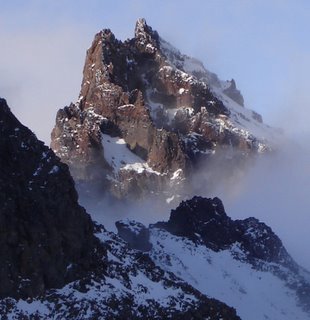
You can see a little patch of blue coming through the clouds, promises of things to come. This is the Worthington Glacier, taken a few minutes before 9 o'clock. I don't know its dimensions. Lets just say that it's big!


The trail up to the top of glacier (a mile long with a 1200 foot elevation gain) was “officially” closed and warning signs were posted regarding the instability of the glacier and the area surrounding it. However, I saw several people scrambling over the rocks and hiking out to it, though they only went to the face of the glacier, not to the top. Two people can be seen in this photo, above and to the right of the trees. (Double-click on the photo to see a larger version.) If you are interested, in July .. several guys hiked to the top of the glacier. They have posted an entry with lots of neat photos at Natural Born Hikers.

If you look real close, you can see that two people are standing at the bottom edge of the glacier, in the center of the picture. Really.

Cropped and enlarged version of the previous photograph. Can you see them now?

To the north and west, the skies were trying to clear. The little lake was formed when the glacier retreated. The drive back to Glennallen in the afternoon more than made up for the dreariness of the morning. Although clouds filled the sky, there was also plenty of sunshine!


The mountains are part of the enormous Wrangell-St. Elias National Park and Preserve.
This last shot was taken when I drove east for a few miles on Alaska Route 10 (Edgerton Highway), which goes to the town of Chitina, 34 miles away. The unpaved McCarthy Road begins at Chitina and ends in 60 miles at the Kennicott River. It's another half mile to McCarthy and five miles further to the town of Kennicott. (Visitors cross the Kennicott River on a footbridge, then walk or take a shuttle to McCarthy and Kennicott.)
“The Milepost” states that the McCarthy Road is recommended for those who like adventurous driving. Motorists should watch for sharp rocks, railroad spikes, no shoulders, narrow sections, soft spots, washboard, potholes and roller-coaster curves. You might think that railroad spikes would be an odd thing to have to be on the lookout for but the McCarthy Road was built on a railroad right of way after the railroad was torn up. You may also think that I'm adventurous, but foolish I'm not and I didn't even attempt to go down McCarthy Road.
The towns of Chitina, McCarthy, and Kennicott are the gateways to the Wrangell-St. Elias National Park and Preserve, which in reality, isn't accessible to the average person. It is wilderness in the truest sense and a haven for experienced backpackers and mountaineers.
Back on the Richardson Highway I stopped at the Visitor Center a few miles south of Glennallen and watched a 22 minute film. That is the only way that I and most people will ever be able to “visit” the park. It looks incredibly beautiful. Wrangell-St. Elias National Park and Preserve is the largest unit of the national park system encompassing nearly 24 million acres. It contains the greatest collection of peaks over 16,000 feet as well as the largest concentration of glaciers on the continent. It is also the reason why it is an almost 600 mile drive from Glennallen to Haines!

Homer is at the end of the Kenai Peninsula in the lower left. Haines is in the lower right corner, a driving distance of approximately 900 miles. The route from Valdez to Haines more or less follows the perimeter of the Wrangell-St. Elias National Park. Skagway is only 15 miles from Haines via ferry but is 300 miles via the highway! The yellow-highlighted routes are the roads that I've traveled thus far. (On the day this post was scheduled – August 24th - I was in Haines.)
I stopped for the night at Tok, which is at the junction of the Alaska Highway, in the middle of the map and 90 miles from the Canadian border.
 The mountain theme last weekend was snow... and lots of it. Here is an image of Little Tahoma taken by Joe Puryear on Saturday at Camp Muir when the weather cleared. The photo below, however, better represents the weather conditions.
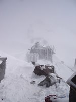 One quick tip: the Muir Snowfield is in EXCELLENT shape for skiing/boarding, especially now that the wet weather has backed off for a few days.


 Little Miss Dutch Maid in the prairie.
 Selling junk.
 Like in most cities in the Netherlands during Queen's Day, there are designated areas and streets that one can sell their (used) wares. And well, some even offer blind date matching services.
 Selling manicure services as well.
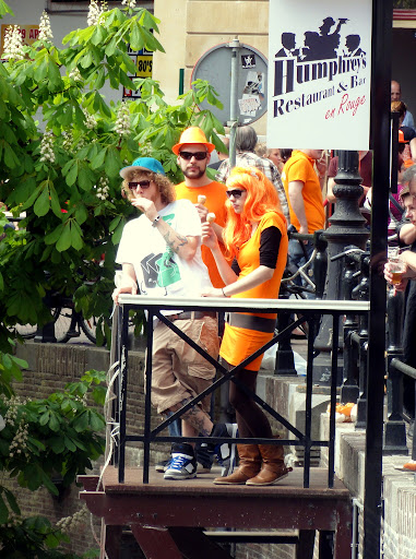
 Dyed orange hair and a Netherlands flag boa are popular outfits for the day.
 It was the first time in many years that it didn't rain during Queen's Day. 20C! These macho tattooed guys are definitely enjoying the day.
 Street games - you hit the button and the girl in bikini goes down the tub of water.
 'Zin in een vluggertje?' literally means 'Want a quickie (sex)?' but this one means a quickie chess game =)
 I know, I know... I am almost 42 (in a few weeks) and I should not be wearing outfits like this. Just trying to be trendy for a day since I have no orange to wear. I don't think I will wear something like this next year.

 I love this umbrella and I found a cocktail stall! Finally mojitos!
 This man is just so cool. Orange bra is it.
 Doing the rumba. Cuba here I come (in 2 weeks!).
 Hollow Man has gone orange.
 Boating is popular during Queen's Day. Unlike in Utrecht, in Amsterdam it gets hectic on the canals (read: boat traffic).
 Best in channelling 'Oranje' and 'Nederland'.
 'Hi, I am Miss Netherlands and we have lots of tulips!'
 Best in creativity: Orange eyelashes for the win!
 Live music of course. They are in every corner. Can you imagine the noise blaring from every corner, I mean everywhere? I am so getting old.
 This man is brave enough to wear a (orange) ribbon on his head.

 More boating fun on Utrecht's Oudegracht.
 The only problem? Well, something about this town just seemed off as soon as we got there.
 It was as if the shadows in the town center were extra shadowy.
 And the sun-lit rooftops exuded a sinister gleam.
 Even the quiet side streets were eerie. What could it be?... Oh yes. There was hardly a bicycle to be seen! Honestly, I cannot remember the last time I saw a town with so few bicycles. Over the past weeks we have been moving our things into the studio and renovating the darkroom, and I've spotted a total of maybe half a dozen bikes in the streets during that entire time period -mostly being ridden on the sidewalks.
 This singular bicycle stood out in No-Bike Town like a lone cowboy. It is an interesting